


- Monday 9:00AM - 5:00PM
- Tuesday 9:00AM - 5:00PM
- Wednesday 9:00AM - 5:00PM
- Thursday 9:00AM - 5:00PM
- Friday 9:00AM - 5:00PM
- Saturday 9:00AM - 12:00PM
- Sunday Closed
Stock #
155-MSDNAVWE
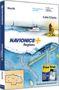
NAVIONICS+ REGIONS MARINE & LAKE CHARTS (NAVIONICS) SD/MSD West
In Stock
Overview
Specifications
Detailed cartography for marine and lakes is updated daily, which makes Navionics+ the perfect choice for cruising, sailing and fishing. Get Nautical Chart, with clear and thorough chart data; the SonarChart™, an exclusive 1 HD bathymetry map; and Community Edits, local content from the community. Daily updates and advanced features are included for 1 yea rand provide you with Dock-to-dock Autorouting1, SonarChart™ Live, Advanced Map Options and Plotter Sync. Simply plug your card into your computer and register at Navionics.com.
- 1 contours
- Daily updates and advanced features for 1 year
- Preloaded with Nautical Chart and SonarChart™ chart layers; Community Edits are downloadable
- Enjoy advanced features such as Dock-to-dock Autorouting1, SonarChart™ Live, Advanced Map Options and Plotter Sync
- Enhance the SonarChart™ contour map with sonar logs you collect
- Check Navionics.com/compatibility
Category Name
Electronics-gps Units & Cartography
Sale Type
New
Manufacturer
Navionics
UPC
821245977076
Hazard
9
LNSuse1
2707376
LNSuse3
2707373
ModuleID
PF_2707173
DMPPartNo
38-3068
KMSPartNo
NAV MSDNAVWE
AS400Description
NAVIONICS+ REGIONAL WEST
VendorItemNumber
MSDNAVWE
Category Name
Electronics-gps Units & Cartography
Sale Type
New
Manufacturer
Navionics
Quantity
1
UPC
821245977076
Hazard
9
LNSuse1
2707376
LNSuse3
2707373
Features
NAV+SO: U.S. South
NAV+NO: U.S. North
NAV+EA: U.S. East
NAV+WE: U.S. West
NAV+CA: Canada & Alaska
- AL, AR, FL, GA, KS, LA, MO, MS, NE, NM, OK, TN and TX
- 1,700 lakes and adding more
- Full marine coverage out to Bimini and West End
NAV+NO: U.S. North
- IA, MI, MN, ND, SD and WI
- 7,700 lakes and adding more
- All of Lake of the Woods, Rainy Lake and U.S. waters of the Great Lakes
NAV+EA: U.S. East
- CT, DE, IL, IN, KY, MA, MD, ME, MI, NC, NH, NJ, NY, OH, PA, RI, SC, TN, VA, VT and WV
- 7,700 lakes and adding more
- Full marine coverage, plus U.S. waters of the Great Lakes
NAV+WE: U.S. West
- AZ, CA, CO, ID, MT, ND, NV, OR, SD, UT, WA and WY
- 2,700 lakes and adding more
- Full marine coverage and Canadian waters of Puget Sound
NAV+CA: Canada & Alaska
- 11,200 lakes and adding more
- Full marine coverage plus border lakes