


- Monday 9:00AM - 5:00PM
- Tuesday 9:00AM - 5:00PM
- Wednesday 9:00AM - 5:00PM
- Thursday 9:00AM - 5:00PM
- Friday 9:00AM - 5:00PM
- Saturday 9:00AM - 12:00PM
- Sunday Closed
Stock #
322-010C120400
LAKEV G3 ULTRA (GARMIN) U.S. East LVUS106F - microSD™/SD™ card
In Stock
Overview
Specifications
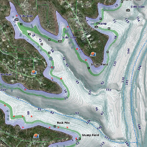
LakeV g3 Ultra inland water maps provide industry-leading coverage, clarity and detail with integrated Garmin and Navionics data, Auto Guidance technology and high-resolution relief shading.
Category Name
Electronics-fishfinders, Chartplotters, Radars, Autopilots, Etc.
Sale Type
New
Manufacturer
Garmin
UPC
753759228040
Hazard
9
LNSuse1
4571111
ModuleID
PF_5090049
DMPPartNo
45-0829
KMSPartNo
GMN 010C120400
AS400Description
US LAKEVIEW G3 ULTRA EAST
VendorItemNumber
010-C1204-00
Category Name
Electronics-fishfinders, Chartplotters, Radars, Autopilots, Etc.
Sale Type
New
Manufacturer
Garmin
Quantity
1
UPC
753759228040
Hazard
9
LNSuse1
4571111
Features
- Thousands of lakes with 1 contours that feature integrated Garmin and Navionics® data
- Auto Guidance technology uses your desired depth and overhead clearance to calculate routes and a suggested path
- Many Garmin Elite survey lakes with up to 1 contours
- High-resolution relief shading combines color and shadow for an easy-to-interpret, clearer view of bottom structure
- Canada card: Covers more than 13,500 HD lakes with up to 1 contours
- U.S. East card: Over 11,500 HD lakes with up to 1 contours and more than 100 Garmin Elite survey lakes
- U.S. West card: Over 5,900 HD lakes with up to 1 contours, and more than 75 Garmin Elite survey lakes
ModuleID
PF_5090049